Ixtoc I Oil Spill Photographs

1979 - 1980. Photographs by E.R. Gundlach unless noted. Contact Info: ErichEti@cs.com

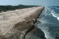
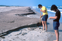
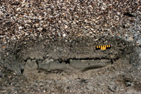
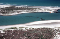
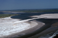
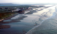
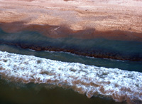
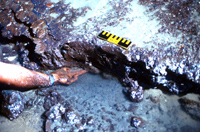
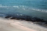
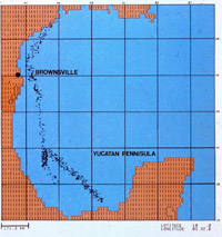
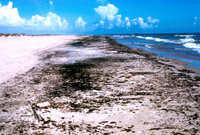
Spill conditions: It is estimated that more than 500,000 tons of crude oil was spilled into the Gulf of Mexico from blowout of the Ixtoc I well offshore in the Bay of Campeche. It occurred in early 1979, and several months later impacted the Texas shoreline, primarily along Padre Island. An early storm in September, reversed the currents and self-cleansed most of the shoreline, leaving only (relatively unusual) tarmats.

Downloads show greater detail. After hitting "download" and bringing up the image, it can be saved to your computer with a right click of your mouse.

Ixtoc I

Ixtoc I slick map prepared by U.S. NOAA. Download.


Ixtoc I
Heavily oiled shoreline, Padre Island. 20 August 1979. Download.
Ixtoc I

Shallow oil penetration (10 cm) into fine-sand Padre Island beach. 18 August 1979. Download.


Ixtoc I
Oiled shell-hash beach, central Padre Island, 11 September 1979. Download.
Ixtoc I
Ground view of oiled shell-hash sediments. Download.
Ixtoc I
Close-up of shell hash indicated substantial oil penetration (>30 cm). Scale = 15 cm. Download.
Ixtoc I
Boom across Mansfield Cut. 16 August 1979. Download.
Ixtoc I
Inlet closure by sand dike to prevent oil entry. 10 September 1979. Download.
Ixtoc I
Storm surge across Padre Island associated with 'norther' storm. 13 September 1979. Most oil was removed from the shoreline during the storm. Download.
Ixtoc I
Tar mat in surf zone. 10 October 1979. Download.
Ixtoc I
Close view of tarmat (20-25 cm thick). Scale = 15 cm. Download.
Ixtoc I
Tar mat remaining after one year and after Hurricane Allen. 25 August 1980. Download.


More Info


Image