We have lead and / or participated in ESIAs related to pipelines, oil, gas and energy development, and marine transport.. These selected summaries show the range of assessments undertaken.
See also:
Environmental Reviews, Audit, Due Diligence and Risk Analyses,
Spill Assessment and Management (using Incident Command System - ICS),
Emergency Response Contingency Planning,
Environmental Sensitivity Analysis and Mapping,
Erosion and Coastal Zone Management, and
Training in Spill Science, Management and Environment.
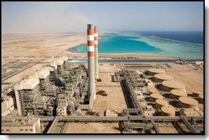
Assessment of Environmental Impact of 13 Power Plants, Western Saudi Arabia
2008-2010,Saudi Energy Company, Western Region, Jeddah
As part of an international team lead by ESCO of Saudi Arabia and EnviroRisk of Canada, we participated in a series of field surveys and air quality assessment with modeling to determine the present state of 13 power plants located in the Western Region of Saudi Arabia. Air quality analyses included field data collection and modeling for particulates, H2S, NOx, SOx and ozone. Geological surveys included subsurface bore holes and sedimentary composition to 15 m or greater. Water analysis included all primary constituents of ground water taken from the bore holes. Notes on surface flora and fauna were also taken. For the marine based power plant / desalination plants, a full spectrum of benthic flora and fauna was taken by divers, and water quality analysis were performed for major constituents and hydrocarbons on water column samples. Results were compared to World Bank, EU and USA standards. Recommendations were made regarding methods to meet the standards where exceedances were found. Preliminary and final results were presented at each of the 13 power plants and to the head office in Jeddah.
Deliverables: Data Collection Methodology, Review of Applicable Legislation, Description of the Environment, Identification of Environmental Impacts, Environmental Management and Mitigation, Environmental Impact Analysis (EIA) for each facility and summarized for all facilities.
Technical Advisor, ESIA for Seismic and Drilling Operations, Kurdistan
2012,Private Companies
For planned seismic surveys and drilling operations,in northern Kurdistan during summer of 2012, a complete ESIA was prepared for submission to Kurdistan authorities and for international review. Dr. Gundlach participated as outside technical reviewer of the documents.
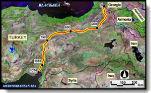
Environmental Management and Risk, BTC Pipeline and Marine Terminal, Turkey
2003-2006, Botas Petroleum Pipeline Corp., Ankara
We lead preparation of numerous environmental plans for the 1074 km (42 inch) BTC Pipeline and Marine Terminal in Turkey. Plans and response drills were approved by the Turkish Government, British Petroleum and World Bank (European) representatives. Plans include:
Oil Spill Response - Incident Management
Wildlife Protection and Response
Aquifer Protection
Sensitivity Maps and Explanatory Atlases for the Pipeline and Marine Terminal, Coastal Erosion Analysis,
Spill Response Procedures
Development of a computer database having over 320 Containment Sites including information on river flow, probable oil spill trajectory movement, environmental and equipment information
All equipment acquisition documents
Response equipment database (internal, government, and private)
Analysis of potential coastal erosion, Ceyhan Terminal
Design and stress calculations for under-jetty fence boom
Environmental risk for Iskenderun Gulf and block valve servicing
Environmental and ICS training
Based on these needs, we developed the procurement specifications and oversaw the purchase of over $7 million of oil spill equipment as well as selection of a spill response contractor responsible for over 75 persons located at four response depots strategically placed along the pipeline.
Gundlach, E.R., H.M. Cekirge, R. Castle, and P. Sutherland, 2005. Oil Spill Response and Equipment for the BTC Pipeline System in Turkey. 2005 International Oil Spill Conference, 6 pp.
Gundlach, E.R., H.M. Cekirge and C. Anul, 2005. Pipeline and Coastal Environmental Sensitivity Mapping for the BTC Pipeline System in Turkey. 2005 International Oil Spill Conference, 6 pp.
Environmental Management Plans (14001) for the BTC Pipeline, Azerbaijan
2002, CCC Contractors, Baku
For the construction stage of the 433 km, 42 inch pipeline in Azerbaijan, we conducted field surveys and prepared the following 14001 Plans:
Waste Management
Spill Response
Environmental Training
Legal Background
Monitoring and Reporting
Performance Evaluation (KPIs)
Emergency Preparedness
Audits and Inspections
Cultural Heritage (Archaeology) Protection
Chemical and Lubrication Oil Storage
Noise Management, Fuel Storage
Waste Minimization
Dust Management
Oil Spill Response
Incident Management
Wildlife Protection and Response
All plans were approved by BP as construction supervisor.
Assessment and Remediation of Lake Maracaibo, Venezuela
1998-2001, PDVSA, Caracas; Bechtel, San Francisco
Dr Gundlach served as Project Co-Director for this 3 year study with the purpose of developing a realistic and scientifically based strategy to improve the water quality of the Lake,
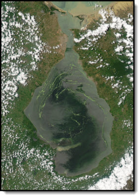
Lake Maracaibo is one of the great oil producing regions of the world and is the center of regional controversy because of perceived detrimental effects from more than 75 years of oil operations. Several negative effects are clearly visible: a green slime caused by the overproduction of algae (eutrophication) is common in many areas, the bottom waters of the Lake are anoxic, and discharges from industrial and municipal sources notably cause local pollution. The oil industry is the primary recipient of criticism concerning the current degradation of the Lake, and is specifically blamed for the discharge of pollutants and oil spills as well as for the navigation channel that enables tanker transport in the Lake, which is assumed to be the principal cause of the anoxia. At the same time, there is widespread public and high-level political support for the construction of a regional omni-port at the entrance to the Lake that would conceivably solve the environmental problems of the Lake by eliminating the channel and removing oil transport in the Lake. At its fullest design, the omni-port would handle petroleum, petrochemicals, coal, general cargo, and duty free trans-shipments, and would cause the relocation of all oil export and import facilities from the Lake at an enormous cost.
Project tasks focused on sources of Lake contamination, the potential environmental benefits to the Lake’s water quality that would be derived by closing the dredged channel and by reducing nutrient inputs, and the economic costs of channel closing. The study team was lead by Bechtel International and included a broad range of scientists and engineers from Venezuela, the United States, Denmark and Australia.
Findikakis, A.N., J. Imberger, I.S. Hansen, L.A. Delgado, R. Garcia-Martinez, and E.R. Gundlach, 2001. A study of environmental remediation options for Lake Maracaibo, Venezuela. International Assoc. of Hydraulic Engineering and Research, Proc. Beijing Conf., 14 pp.
Gundlach, E., A. Findikakis, L. Delgado and A. Harding, 2001. Remediation and transportation planning, Lake Maracaibo, Venezuela. 2001 International Oil Spill Conference, American Petroleum Institute, Wash. DC, p. 1174-1179.
Environmental Risk and Response Planning, Natural Gas and Gas Liquids Camisea Pipeline, Peru
2006-2008, InterAmerican Development Bank (IADB)
We lead the review Detailed review of the environmental risk and preparedness of the Camisea pipelines extending 560 km across the Andes Mountains in southern Peru. All work was conducted in Spanish with no translator required.
Tasks included:
Analysis and recommendations of spill model output delineating concentrations in the water column and ability to recover.
Equipment analysis, strategy, site locations and recommendations.
Review of equipment applied to national conditions.
Training course requirements, auditing and verification..
Review of Tier 1 and 2 response equipment depots, and procedures for Tier 3 callout.
Development and participation as reviewer of an international oil spill response exercise to receive Bank approval of their Plan.
Review analysis of fire, flashover and explosion.
Recommendations for environmental and social components (sensitivity analysis) to be included, and format.
Audit of equipment bases and transport (helicopter and ground) systems and procedures.
Verification of maintenance and tracking programs.
Recommendations were accepted and incorporated into the final Plan, including:
Descripción del Proyecto (Project Description)
Riesgo / Reducción del Riesgo (Risk / Risk Reduction)
Prevención de Incidentes (Incident Prevention)
Escenarios (Scenarios)
Estrategias de Respuesta (Response Strategies)
Tecnicas de Respuesta (Response Techniques)
Acciones Especificas de Control (Specific Control Actions).
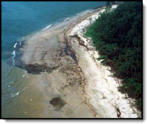
The 12 January 1998 rupture of a 24-inch pipeline from the IDOHO platform to the Mobil Qua Iboe terminal resulted in the release of approximately 40,000 bbl of light Nigerian crude oil. Because of rapid westerly transport, dispersants were the method of primary response, with approximately 250 barrels being applied. Also, because over 90% of the oil was dispersed offshore, heavy shoreline oiling was limited and localized. However, due to westward transport by nearshore currents, remnants of the spill tracked 5-10 km offshore from the spill source was observed at Lagos harbor, about 900 km away.
Oiling of interior, sensitive mangrove habitats was limited to a few locations. Exposed sand beaches self-cleaned within 2-3 weeks. Cleanup of heavily impacted shoreline areas recovered approximately 1000 bbl of oily waste. A national and international team of scientists was activated within 24 hours and directed toward measuring impact on environmental resources important to local human activities.
Elements of the scientific program were (1) offshore components, including fisheries, benthos, chemistry, microbiology, (2) riverine/estuary, including extensive water analysis to detect any spill input to water resources used by local settlements and chemical analysis of local fish market samples. Preliminary results indicated that any initial environmental effects were limited and localized. Based on the initial program, a larger followup program is planned involving offshore studies, a shoreline fate and effects program, impact to mangrove habitats, and a study of any socioeconomic and human health effects.
In addition to project management and field assessment activities, court testimony was also provided in Nigerian Federal Court regarding observations of oil impact and effects.
Inyang, L.E.D., G.E. Essien, B.S. Moses, E.R. Gundlach, E.S. Gilfillan, and D.S. Page, 2002. Analysis of Potential Effects of the Idoho-QIT Oil Spill on River-Estuarine Fisheries in Nigeria. In: Proceedings of the 25th Arctic and Marine Oil Spill Program (AMOP) Technical Seminar, Environment Canada, p. 941-957.
Olagbende, O.T., G.O. Ede, L.E..D. Inyang, E.R. Gundlach, E.S. Gilfillan and D.S. Page, 1999. Scientific and cleanup response to the Idoho-QIT oil spill, Nigeria. Environmental Technology, vol. 20, p. 1213-1222.
Environmental Impact, Risk Analysis and Contingency Plan, Gas Pipeline Transport and Distribution System, Chile
1995-1996, British Gas / ENAP / Tenneco, Santiago
A 600-page Environmental Impact Analysis was prepared for the Distribution System for the 800-km gas pipeline from Argentina to Chile for British Gas/Tenneco/ENAP. In addition to environmental, technical, and legal descriptions of the Project, work elements included a Risk Analysis and Contingency Plan for all Phases of the Project. The C-Plan included operations to be performed under a set of defined emergencies, and the roles and responsibilities of TransGas personnel in each case.
The project was conducted in Spanish and English, with over 30 investigators preparing various components on the EIA. All final reports were prepared in Spanish and submitted to Chilean Government for approval. A GIS mapping system was used to rapidly assemble base maps, the pipeline route, and environmental overlays.
Contents prepared in Spanish and English include:
1.0 JURÍDICO AMBIENTAL APLICABLE (Applicable Environmental Legislation)
2.0 DESCRIPCÍON DEL PROYECTO (Project Description)
3.0
LÍNEA BASE MEDIO AMBIENTE FISICO (Physical Environmental Baseline)
4.0 LÍNEA BASE VEGETACÍON Y FLORA URBANA (Vegetation and Urban Flora)
5.0 LÍNEA BASE MEDIO AMBIENTE SOCIOECONÓMICO Y CALIDAD DE VIDA (Socio-encomics and Quality of Life)
6.0 EVALUACÍON DE IMPACTOS AMBIENTALES (Evaluation of Environmental Impacts)
7.0 ANALISIS DE RIESGO OPERACIONAL (Analysis of Operational Risk)
8.0 PLAN DE MITIGACÍON Y COMPENSACÍON (Mitigation and Compensation Plan)
9.0 PLAN DE MEDIDAS RESTAURADORAS (Restoration Measures)
10. PLAN DE MITIGACÍON DE RIESGOS (Risk Mitigation Plan)
11. PLAN DE CONTINGENCIA (Contingency Plan)
Environmental Impact Analysis of the Trans-Panama Pipeline, Panama
1983-1984, British Gas / ENAP / Tenneco, Santiago
Physical and ecological base-line data were collected to determine potential impacts of a 36-inch pipeline built across western Panama to transfer Alaskan crude oil from the Pacific Coast to the Atlantic Coast. The project includes an impact analysis of two marine terminal areas constructed in association with the pipeline: Laguna de Chiriqui (Atlantic side) and Bahia de Chiriqui (Pacific side). Ecological data collected included types and relative abundance of marine fisheries, distribution of intertidal and subtidal benthos, and primary habitat locations for marine birds, turtles, and mammals. A laboratory study of oil toxicity on resident lobsters and shrimp also was undertaken. Current meter arrays (two Atlantic, one Pacific), drogue and dye studies, meteorological stations (one Atlantic, one Pacific), salinity/temperature/depth measurements, and a recording tide and wave gauge were all used to characterize the physical conditions present around each oil terminal. Utilizing the derived information, a computer model was generated to realistically project the transport of spilled oil during typical wet and dry season conditions. In addition, shoreline types were characterized and ranked as to overall sensitivity to spilled oil to provide a basis for contingency planning and to direct the response effort in protecting the most sensitive habitats.
Final reports include a technical report (shoreline sensitivity, ecological studies, trajectory analysis, oil toxicity studies, and a compendium of oil impact data from previous studies’ data summaries), and four coastal and marine resource sensitivity maps. Recommendations for pollution control measures at each terminal were instituted by the pipeline operating company.
Gundlach, E.R., I.F. de Vincenti, G. Moss, and J. Janssen. 1985. Resource mapping and contingency planning, PTP pipeline facilities, Panama. International Oil Spill Conf.
Environmental Characterization / Baseline, Niger River Delta, Nigeria
For the Niger Delta Environmental Survey, a non-governmental organization concerned about the welfare of the Delta inhabitants, an extensive four-part Study of the Delta environment was undertaken. Working with ERML (Lagos) and Nigerian scientists from several Universities, a 200+ page report was completed for each part of the Study, including the following:
A detailed analysis of all published and unpublished information regarding the Delta
An evaluation of the operational definition of the Delta
A description of the Delta’s primary physical and biological features
The socio-economic characteristics of the region
The major problems of the region, including impacts of upstream development and constraints to sustainable development
Data needed to set policy regarding sustainable development of the Delta
Environmental Assessment of an Iron Pelletizing Plant, Chile
1994-1995, Compañia Acero del Pacífico, Santiago
An assessment was conducted of a large iron pelletizing plant in Huasco, Chile, particularly related to air and water discharges. Completed by other members of the team, the air work focused on impact (loss of productivity) to the adjacent olive groves. The water discharge evaluation comprised an analysis of water quantity and quality, location, and effects on the bottom. Data for water chemistry, suspended sediment, bottom profile and biological characterizations were available and evaluated. Specific measures to enhance the environmental performance of the facility were recommended.
Environmental Impact of Oil Operations, Argentina
1992-1993,Astra C.A.P.S.A., Buenos Aires
An environmental assessment of all Astra operations in Argentina was conducted, including well sites, pipelines, gathering and pumping stations, separation units, land fills, tank farms, etc. The plan denoted and ranked environmental concerns, and then developed both mitigation measures and a plan to monitor improvement for each environmental issue. The assessment recognized both the environmental problems associated with Astra operations and the improvements being made. The Environmental Assessment was submitted and approved by the Argentine government in conformance with Resolution 103/92.
Gundlach, E.R. y H. Rizzato. 1994. Estudio de evaluación ambiental del yacimiento Dadin (Res. 105/92 SE). Informe para Astra C.A.P.S.A., 115 pp.
Gundlach, E.R. y H. Rizzato. 1994. Estudio de evaluación ambiental del yacimiento Vizcacheras (Res. 105/92 SE). Informe para Astra C.A.P.S.A., 125 pp.
Gundlach, E.R., H. Rizzato, E. Nastri, and A. Murut. 1995 New oil spill environmental protection and contingency plan requirements - Argentina. International Oil Spill Conference,
Environmental Characterization of 110 Proposed Marine Sanctuary Sites (USA and Territories)
NOAA Office of Marine Sanctuaries, Wash., DC
The primary purpose of this project was to participate in site selection and to provide detailed physical, ecological, and human-use descriptions of 110 proposed National Marine Sanctuary sites selected within the United States and its territories.
The primary role was to participate in regional meetings regional meetings [North Atlantic, South Atlantic, Gulf Coast, Great Lakes, Eastern Pacific, Western Pacific (Guam, Samoa, etc.), Alaska, and Caribbean (Puerto Rico and the Virgin Islands] and provide written characterizations for all selected sites. Summaries included a physical description of the area, primary rationale for inclusion as a marine sanctuary site (ecological, geological, recreational, etc.), a characterization of the site's natural resources and human-use components, a listing of primary reference material, and a map of the site. Altogether, the number of sites selected for the final list of candidate sanctuary sites was as follows: Caribbean (2), East Pacific (5), Great Lakes (5), Gulf of Mexico (5), North Atlantic (5), South Atlantic (5), and Western Pacific (5). Announcement of sites in Alaska was temporarily postponed (12 sites were selected as preliminary candidates).
Environmental Impact Analysis of Proposed Refinery, South Carolina
State of South Carolina, Columbia
This study was part of an environmental impact analysis to determine the probable consequences of locating a mini-refinery at Georgetown, South Carolina, at the head of a relatively pristine, marsh-dominated estuary. The project involved study of the ecology of Winyah Bay, with special emphasis on endangered species, economic impact on the area, study of air quality problems, and analysis of potential oil pollution effects. It was found that although the facility would provide employment for 100 to 130 people, the ecological consequences of a major oil spill in Winyah Bay would have severe economic costs by loss of jobs in the marine institution and great ecological impacts to the area's fish and wildlife.
The proposed refinery was unable to receive the necessary state permits and was never built.
EIA for Beach Renourishment, South Carolina
City of Myrtle Beach
The shoreline of Myrtle Beach is a major economic resource to the state of South Carolina, providing over $5 million/day in summary revenues. Unfortunately, the combination of shore-protection practices and natural processes over the last 30 years has caused severe erosion over several stretches of the developed shoreline. As part of an overall, five-year development plan to enhance the recreational value of the beach as well as to protect existing shorefront structures, the City of Myrtle Beach undertook a 1-million cubic yard nourishment project. ADL personnel directed the geotechnical studies concerning the location and analysis of potential offshore borrow sources.
For this aspect of the project, over 60 vibracores were taken at offshore sites located using shore-based, trisponder locations. After core logging on deck of the 75-ft research vessel, each core was split, sampled, described, and photographed. Sediment analyses including grain size and carbonate fraction, were performed on each sample. Environmental studies were undertaken simultaneously to determine resident benthic populations and potentially affected beach flora and fauna, and to provide methods of mitigating impacts. Based on these analyses, it was determined that the grain size was too fine for adequate beach replenishment and that land sources should be utilized.
Gundlach, E.R., B.J. Baca, M.W. Williams, T.W. Kana. Geotechnical and biological assessment of the Myrtle Beach area in preparation for offshore dredging. Submitted to City of Myrtle Beach. 250 pp.
 As part of an international team lead by ESCO of Saudi Arabia and EnviroRisk of Canada, we participated in a series of field surveys and air quality assessment with modeling to determine the present state of 13 power plants located in the Western Region of Saudi Arabia. Air quality analyses included field data collection and modeling for particulates, H2S, NOx, SOx and ozone. Geological surveys included subsurface bore holes and sedimentary composition to 15 m or greater. Water analysis included all primary constituents of ground water taken from the bore holes. Notes on surface flora and fauna were also taken. For the marine based power plant / desalination plants, a full spectrum of benthic flora and fauna was taken by divers, and water quality analysis were performed for major constituents and hydrocarbons on water column samples. Results were compared to World Bank, EU and USA standards. Recommendations were made regarding methods to meet the standards where exceedances were found. Preliminary and final results were presented at each of the 13 power plants and to the head office in Jeddah.
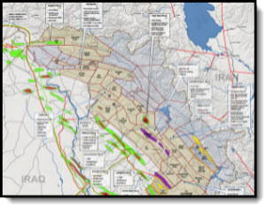 For planned seismic surveys and drilling operations,in northern Kurdistan during summer of 2012, a complete ESIA was prepared for submission to Kurdistan authorities and for international review. Dr. Gundlach participated as outside technical reviewer of the documents.
 Dr Gundlach served as Project Co-Director for this 3 year study with the purpose of developing a realistic and scientifically based strategy to improve the water quality of the Lake,
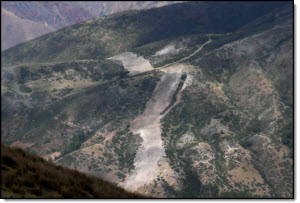
 terminal resulted in the release of approximately 40,000 bbl of light Nigerian crude oil. Because of rapid westerly transport, dispersants were the method of primary response, with approximately 250 barrels being applied. Also, because over 90% of the oil was dispersed offshore, heavy shoreline oiling was limited and localized. However, due to westward transport by nearshore currents, remnants of the spill tracked 5-10 km offshore from the spill source was observed at Lagos harbor, about 900 km away.
 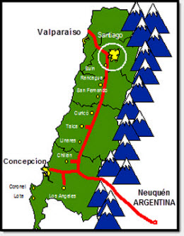 A 600-page Environmental Impact Analysis was prepared for the Distribution System for the 800-km gas pipeline from Argentina to Chile for British Gas/Tenneco/ENAP. In addition to environmental, technical, and legal descriptions of the Project, work elements included a Risk Analysis and Contingency Plan for all Phases of the Project. The C-Plan included operations to be performed under a set of defined emergencies, and the roles and responsibilities of TransGas personnel in each case.
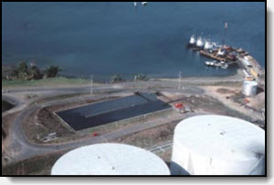 Physical and ecological base-line data were collected to determine potential impacts of a 36-inch pipeline built across western Panama to transfer Alaskan crude oil from the Pacific Coast to the Atlantic Coast. The project includes an impact analysis of two marine terminal areas constructed in association with the pipeline: Laguna de Chiriqui (Atlantic side) and Bahia de Chiriqui (Pacific side). Ecological data collected included types and relative abundance of marine fisheries, distribution of intertidal and subtidal benthos, and primary habitat locations for marine birds, turtles, and mammals. A laboratory study of oil toxicity on resident lobsters and shrimp also was undertaken. Current meter arrays (two Atlantic, one Pacific), drogue and dye studies, meteorological stations (one Atlantic, one Pacific), salinity/temperature/depth measurements, and a recording tide and wave gauge were all used to characterize the physical conditions present around each oil terminal. Utilizing the derived information, a computer model was generated to realistically project the transport of spilled oil during typical wet and dry season conditions. In addition, shoreline types were characterized and ranked as to overall sensitivity to spilled oil to provide a basis for contingency planning and to direct the response effort in protecting the most sensitive habitats.
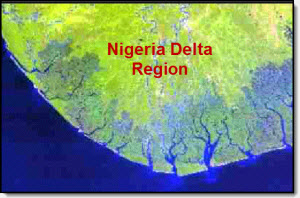 For the Niger Delta Environmental Survey, a non-governmental organization concerned about the welfare of the Delta inhabitants, an extensive four-part Study of the Delta environment was undertaken. Working with ERML (Lagos) and Nigerian scientists from several Universities, a 200+ page report was completed for each part of the Study, including the following:
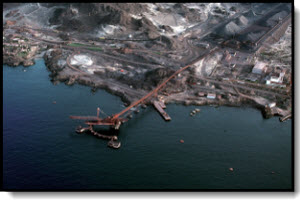 An assessment was conducted of a large iron pelletizing plant in Huasco, Chile, particularly related to air and water discharges. Completed by other members of the team, the air work focused on impact (loss of productivity) to the adjacent olive groves. The water discharge evaluation comprised an analysis of water quantity and quality, location, and effects on the bottom. Data for water chemistry, suspended sediment, bottom profile and biological characterizations were available and evaluated. Specific measures to enhance the environmental performance of the facility were recommended.