Extensive training in coastal geomorphology has provided a solid basis to provide a variety of supporting services related to
coastal zone management and assessment, including:
Analysis and cause of coastal and riverine erosion,
Historic analysis of shoreline position and changes,
Guidance for coastal zone management,
Calculations of sedimentary transport, and the
Analysis and mitigation of coastal hazards.
In 2012, Dr. Gundlach provided a chapter for the forthcoming Encyclopedia of Coastal Hazards to be published by Springer Publishing Company.
Example projects are presented below.
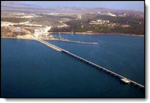
Erosion Potential at the BTC Export Terminal, Ceyhan, Turkey
Botas, Ankara
To fulfill environment requirements of international lenders a detailed geomorphic and modeling study was completed of the area in and around the planned construction of a 3 km long export jetty for the Baku-Tbilisi-Ceyhan Pipeline originating in Azerbaijan and scheduled to export 1.2 million barrels per day. The analysis showed very stable sand pocket beaches anchored by volcanic bedrock that would be little influenced by jetty construction.
Erosion in the Niger River Delta Area, Nigeria
Niger Delta Environmental Survey, Lagos
For the Niger Delta Environmental Survey, a non-governmental organization concerned about the welfare of the Delta inhabitants, an extensive four-part Study of the Delta environment was undertaken. Working with ERML (Lagos) and Nigerian scientists from several Universities, a 200+ page report was completed for each part of the Study, including a description of erosion losses and location.
Environmental Liabilities Associated with US Dredging Operations
Private Client
As part of the purchase of one of the world's largest dredging corporation, a review was conducted of dredging impacts from projects undertaken along the coasts of the United States. Specialists in industry and the government were interviewed concerning all environmental aspects of the dredging operation. Of most common concern was the placement of contaminated sediments in unlined and open disposal sites. Other issues concerned the presence of pipes and cables left behind after the completion of the project. In rarer instances, sediment was discharged into the wrong location. In a few instances legal actions had to be taken to ensure conformance with standard procedures to protect the environment.
Analysis of Historic Shoreline Position, Rockport, Massachusetts
Private Client
For a landowner in dispute with shoreline property ownership, we analyzed the historic position of the
shoreline dating back to the early 1700's. A variety of map sources were found including the port construction plans from the early 1800s.
Maps were scanned and entered into a Geographic Information System (GIS) which enabled overlay of each shoreline into
a single database. Results showed that the wharf was built on the shoreline position at the time. Material and testimony was presented
to support the landowner in a court hearing.
Sediment Dynamics and Shoreline Changes, Connecticut
Mumford Cove Association
Mumford Cove embayment experienced substantial vegetation growth and possible infilling as a consequence of excessive nutrient loading due to the discharges by a primary treatment plant. The purpose of this project was to obtain a general understanding of the sedimentary dynamics of the Mumford Cove area, particularly as it related to infilling of the cove and shoreline changes.
The project involved field surveys and the interpretation of aerial photographs. Data from the field surveys yielded information concerning beach stability, grain size and sediment movement. The shoreline present in aerial photographs was digitized and overlaid computer-graphically. Photographs from 1934, 1950, 1959, 1969, 1975, 1980, and 1986 were used. Results indicated a substantial growth of a split along the western shoreline with the simultaneous loss of shoreline to the southwest. No major sediment infilling was noted.
Shoreline Changes and Setback Analysis, Rhode Island
Private Client
In conformance with regulations promulgated by the Rhode Island Coastal Resources Management Council (CMRC), a shoreline analysis and designation of the shoreline setback line were undertaken for a private corporation. The shoreline analysis entailed field and aerial photographic studies. Field work included measurement of beach profiles and sediment analysis to determine inherent shoreline stability under normal and storm conditions. Shoreline position, determined from photographs dating back to the 1940's was digitized and compared computer-graphically. Distortions due to scale changes were thereby eliminated. The shoreline setback work entailed the exact positioning of the shoreline as designated by CMRC regulations. This included natural, mixed sand and gravel shores, marshes, wetlands, and bluffs, as well as a large section of shoreline infilled with concrete rubble.
Erosion Analysis and Design Criteria, Molume Channel, Nigeria
Chevron Nigeria
This study determined the extent of natural erosion along the Molume area of the Niger Delta, and the influence of cut channels on the natural erosion rate. The study consisted on an intensive field survey during which hydrographic parameters were measured along the exposed ocean side of the delta and within interior channels. Parameters included wave height, period, direction, temperature, soils, salinity, tidal height, and suspended sediment. Detailed distances were measured using electronic positioning equipment.
Results indicate that this area in general has one of the highest rates of erosion in the world, losing several meters of mangrove-dominated shoreline annually. Canals cut through the Delta for access to drilling sites and for commerce tend to act as conduits for the discharge of interior waters to the Atlantic, increasing current velocities, and, therefore, increasing erosion. Using computer models to generate potential wave heights across the shallow offshore region, coupled with soil analyses, permitted development of a set of criteria which were used to formulate the design of an erosion-prevention device that could be used to prevent further erosion at this site. The proposed structure, for which a preliminary design was submitted, consists of a modified cellular cofferdam, driven deep into the sediments.
Evaluation of Shoreline Structures, Brittany, France
Amocot
This project involved the review and analysis of hundreds of engineered structures placed along the Brittany shoreline. Structures were reviewed in terms of necessity of construction, performance, cost, and materials used. It was determined that a majority of the structures were ill-placed and conflicted with other methods of preserving the shoreline, particularly the use of sand fences and replanting methods. Other projects were well-conceived and executed, including the creation of restricted walking and parking areas in dune fields. The major financial projects dealt with the rebuilding of seawalls for the protection of harbor facilities.
Gundlach, E.R. 1987. Coastal zone management practices, northwestern Brittany. Coastal Zone '87, The Fifth Symposium on Coastal and Ocean Management, Seattle, WA, vol.4, p. 4463-4475.
Pre-Dredging Geo-Technical Evaluation for Beach Renourishment, South Carolina
City of Myrtle Beach
T he shoreline of Myrtle Beach is a major economic resource to the state of South Carolina, providing over $5 million/day in summary revenues. Unfortunately, the combination of shore-protection practices and natural processes over the last 30 years has caused severe erosion over several stretches of the developed shoreline. As part of an overall, five-year development plan to enhance the recreational value of the beach as well as to protect existing shorefront structures, the City of Myrtle Beach undertook a 1-million cubic yard nourishment project. This project included supervision of the geotechnical studies concerning the location and analysis of potential offshore borrow sources.
For this aspect of the project, over 60 vibracores were taken at offshore sites located using shore-based, Trisponder locations. After core logging on deck of the 75-ft research vessel, each core was split, sampled, described, and photographed. Sediment analyses including grain size and carbonate fraction, were performed on each sample. Environmental studies were undertaken simultaneously to determine resident benthic populations and potentially affected beach flora and fauna, and to provide methods of mitigating impacts. Based on these analyses, it was determined that the grain size was too fine for adequate beach replenishment and that land sources must therefore be utilized.
A detailed impact analysis was undertaken to describe the potential effects of offshore dredging. A 3-year monitoring program was proposed.
Gundlach, E.R., B.J. Baca, M.W. Williams, T.W. Kana. Geotechnical and biological assessment of the Myrtle Beach area in preparation for offshore dredging. Submitted to City of Myrtle Beach. 250 pp.
Erosion Analysis, Escravos Terminal, Nigeria
Chevron, Nigeria
The oil terminal and export facility near the mouth of the Escravos River, Nigeria, shows several indications of moderate to severe erosion. Through a combined field and modeling program, the rate and probable cause of erosion was determined for the facility and the adjacent village. The field study collected current, tide, and bathymetric data from the Escravos River, as well as from the numerous tidal creeks along the edges of the facility. The model studies were used to determine the effects of waves on the front of the facility and to predict current patterns after placement of various structural designs along the front of the facility. Based on these studies, measures were recommended to stabilize the area. Certain structural designs were also recommended to be avoided. The construction of a sand-bag / stacked revetment was offered as an inexpensive method of improving the stability of the facility’s riverfront.
Gundlach, E.R., M. Murday, M.L. Spaulding, K. Jayko, T. Isaji. Measures to control erosion at Escravos Terminal, Nigeria. Prepared for Gulf Oil Company (Nigeria) Ltd., 113 pp.
Erosion Impact and Mitigation, Atlantic City, New Jersey
Private Client
During winter, a deflation (erosion) zone formed along the backshore areas along the beach fronting a condominium development site in Atlantic City, New Jersey. The purpose of this project was to determine the causes of the erosion recommend alternatives for its elimination. By the time of the survey, the deflated area measured greater than 140 ft by 140 ft and extended several feet deep. A water main of the city became exposed by this erosion and was of community concern.
Based on transects across the area, results of grain-size analyses, and review of photographs, it was determined that this deflation zone was caused by northerly-to-westerly winds that increase in velocity as they blow from back to front across the Enclave. Calculations indicate that wind velocities of 17 knots or greater are necessary to transport 95 percent of the sand particles currently found on the beach (mean grain size = 0.19 mm). Analyses also indicated that sand grains larger than 1 mm can resist winds of approximately 27 knots and, therefore, are quite stable on the beach. Recommendations included infilling the deflated area with either a surface or underlying material (sand) coarser than 1 mm. The recommended technique consists of a bottom layer of regular beach sand with a 30-cm surface layer of greater than 1mm sand.
Gundlach, E.R., and S.J. Siah. Cause and elimination of the deflation zones along the Atlantic City (New Jersey) shoreline. Coastal Zone '87. The 5th Symposium on Coastal and Ocean Management, Seattle, WA, Vol 2, p. 1357-1370.
 To fulfill environment requirements of international lenders a detailed geomorphic and modeling study was completed of the area in and around the planned construction of a 3 km long export jetty for the Baku-Tbilisi-Ceyhan Pipeline originating in Azerbaijan and scheduled to export 1.2 million barrels per day. The analysis showed very stable sand pocket beaches anchored by volcanic bedrock that would be little influenced by jetty construction.
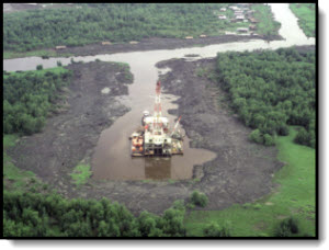 For the Niger Delta Environmental Survey, a non-governmental organization concerned about the welfare of the Delta inhabitants, an extensive four-part Study of the Delta environment was undertaken. Working with ERML (Lagos) and Nigerian scientists from several Universities, a 200+ page report was completed for each part of the Study, including a description of erosion losses and location.
  For a landowner in dispute with shoreline property ownership, we analyzed the historic position of the
shoreline dating back to the early 1700's. A variety of map sources were found including the port construction plans from the early 1800s.
Maps were scanned and entered into a Geographic Information System (GIS) which enabled overlay of each shoreline into
For a landowner in dispute with shoreline property ownership, we analyzed the historic position of the
shoreline dating back to the early 1700's. A variety of map sources were found including the port construction plans from the early 1800s.
Maps were scanned and entered into a Geographic Information System (GIS) which enabled overlay of each shoreline into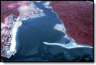 Mumford Cove embayment experienced substantial vegetation growth and possible infilling as a consequence of excessive nutrient loading due to the discharges by a primary treatment plant. The purpose of this project was to obtain a general understanding of the sedimentary dynamics of the Mumford Cove area, particularly as it related to infilling of the cove and shoreline changes.
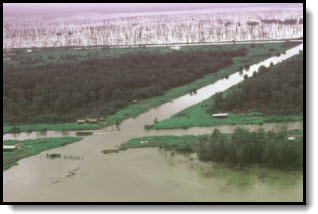 This study determined the extent of natural erosion along the Molume area of the Niger Delta, and the influence of cut channels on the natural erosion rate. The study consisted on an intensive field survey during which hydrographic parameters were measured along the exposed ocean side of the delta and within interior channels. Parameters included wave height, period, direction, temperature, soils, salinity, tidal height, and suspended sediment. Detailed distances were measured using electronic positioning equipment.
 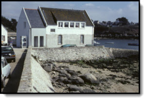 This project involved the review and analysis of hundreds of engineered structures placed along the Brittany shoreline. Structures were reviewed in terms of necessity of construction, performance, cost, and materials used. It was determined that a majority of the structures were ill-placed and conflicted with other methods of preserving the shoreline, particularly the use of sand fences and replanting methods. Other projects were well-conceived and executed, including the creation of restricted walking and parking areas in dune fields. The major financial projects dealt with the rebuilding of seawalls for the protection of harbor facilities.
 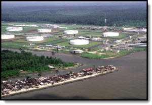 The oil terminal and export facility near the mouth of the Escravos River, Nigeria, shows several indications of moderate to severe erosion. Through a combined field and modeling program, the rate and probable cause of erosion was determined for the facility and the adjacent village. The field study collected current, tide, and bathymetric data from the Escravos River, as well as from the numerous tidal creeks along the edges of the facility. The model studies were used to determine the effects of waves on the front of the facility and to predict current patterns after placement of various structural designs along the front of the facility. Based on these studies, measures were recommended to stabilize the area. Certain structural designs were also recommended to be avoided. The construction of a sand-bag / stacked revetment was offered as an inexpensive method of improving the stability of the facility’s riverfront.