MAJOR SPILL ASSESSMENTS AND TECHNICAL ADVISEMENT ICS (INCIDENT COMMAND SYSTEM) SPILL MANAGEMENT
These selected summaries show the range of major assessments undertaken. See also:
Environmental and Social Impact Assessments,
Environmental Audits, Due Diligence and Environmental Risk Analyses,
Emergency Response Contingency Planning,
Environmental Sensitivity Analysis and Mapping,
Erosion and Coastal Zone Management, and
Training in Spill Science, Management and Environment.
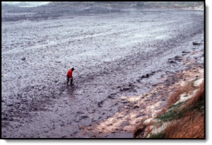
Exxon Valdez (Shoreline Assessment and Bio Effects Review)
1989-1990, 2007-2012
This project included advisement and supervision on the response management organization, potential impacts, public relations, damage assessment, computer/database systems for response tracking, supervision of shoreline observation teams, testing of shoreline cleaning agents, and, in general, all activities associated with the cleanup, as well as providing liaison between the State, Federal agencies, and Exxon, concerning integration of scientific studies and mapping systems and procedures. Response advisement continued for two years.
Customizing available GIS software and connecting with ARC/INFO, a series of detailed databases were developed to capture more than 25 separate sets of environmental data collected during the response and damage assessment phases of the spill. Data within the GIS included:
Spill location derived from field overflights.
Shoreline impacts derived from overflight and ground surveys,
Station data: physical, biological, and chemical,
Profile data: topography, oil thickness, penetration, and coverage,
Cleanup data: oil characteristics, cleanup type, and inspection records,
Photographic (video and still) data, and
Sensitivity ranking of shoreline types.
In 2011, Dr. Gundlach reviewed the major biological programs undertaken to assess effects of oil and cleanup on shoreline biota.
Gundlach, E.R., 2011. Using ShoreZone Imagery to Improve Environmental Sensitivity Maps. International Oil Spill Conference.
Boehm, P.D., D. Page, J.M. Neff, E.R. Gundlach, and J.S. Brown. 2011. Long-Term Fate and Persistence of Oil from the Exxon Valdez Oil Spill: Lessons Learned or History Repeated.
Gundlach, E.R., E.A. Pavia, C. Robinson, and J.C. Gibeaut. 1991. Shoreline surveys at the Exxon Valdez oil spill: the State of Alaska response. International Oil Spill Conference, p. 519-529.
Gundlach, E.R. and S. Provant, J. Bauer, and R. Bayliss. 1990. Response by the Alaska Department of Environmental Conservation to the Exxon Valdez oil spill. In: Specialty Conference on Oil Spills, Management and Legislative Implications, ASCE, NY, NY 10017, p. 471-478.
Deepwater Horizon, Louisiana, Gulf of Mexico (Boom Strategy Support)
2010
E-Tech provided technical support for developing boom strategies and costs to protect Louisiana embayments.
E-Tech provided supporting information and trial testimony about shoreline impacts, movement of oil, and conditions related to the accident as part of a class action suit.
World Bank Study of Jiyeh Power Plant Spill, Lebanon
2006-2007, World Bank, Washington, DC
The storage tanks of the coastal Jiyeh electrical power plant in southern Lebanon were hit by Israeli bombs in July 2006. As a result, part of the oil was burned while the rest, approximately 15,000 tons, was released into the adjacent Mediterranean Sea. The task was to complete an economic evaluation of the impacts based on injury to natural resources (fish, bottom fauna, birds, subtidal biota, marine mammals, and marine turtles) and direct and indirect losses to coastal communities, including hotels, restaurants, fisheries, national parks, and other entities sustaining losses. The overall damage and cleanup costs are conservatively estimated to be about US$ 203 million, or 1 percent of Lebanon's GDP in 2006.
Ikaheimo, E. and E. Gundlach, 2007, Economic Assessment of Environmental Damages Caused by the Jiyeh Oil Spill During Recent Hostilities in Lebanon (July – August 2006). World Bank Group, Washington D.C. 53 pp.
World Bank Publication: Chapter 6. Oil Spill and Waste Due to Conflict: the Case of Lebanon.58 pp.
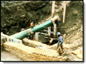
Nearshore Recovery and Controlled Burning, Attaturk Reservoir, Turkey
2005
In April 2005, a leak of an estimated 40,000 barrels occurred in rural southeastern Turkey. The cause was attributed to an excavator which damaged, but did not break the pipe. The break occurred because of a pressure build up due to a pig stuck at the damaged location. Oil traversed a drainage ditch and went into one of the largest lakes in Turkey, spreading over tens of km of shoreline and offshore waters.
Our operation focused on shoreline protection and recovery, directing a staff of over 75 cleanup workers and many small boats. Due to equipment limitations, a heavy reliance was made on the use of sorbent booms to contain and control the oil along the shoreline and in-situ burning. More than 30 in-situ burns were carried out, removing most of the oil trapped in shoreline coves and pockets. Final removal of residue was made by hand.
Swanson Creek Spill, Maryland (Planning Section Chief)
2001-2003
On the evening of 7 April 2000, a leak in a 12-inch underground pipeline bringing fuel oil to a large power station was detected. Altogether approximately 126,000 gallons leaked into the adjacent marsh and then into the Patuxent River. In spite of boom rapidly being deployed, oil spread some 17 miles to the south, eventually oiling a total of 40 miles of shoreline. Oiled habitats include extensive marsh areas, narrow fringing marshes, sand beaches, riprap and harbor structures, and some mud-dominated flats.
As part of the Spill Management Team (Planning Section Chief), activities performed included overall management of planning and scientific surveys which were carried out for a period of seven months. In addition to developing over 50 Incident Action Plans, numerous other documents were prepared including an assessment of alternative technologies and a summary of cleanup activities for the first year. The total cost of the spill may reach $90 million. At its peak, the Team managed over 1000 spill cleanup responders. Activities were mostly ended in Fall 2000, although monitoring and shoreline surveys continued into summer 2001. A GIS ArcView mapping system was used to monitor shoreline conditions and prepare maps indicating oiling conditions and cleanup status.
Gundlach, E., B. Baca and D.C. Barry. 2003. Emergency marsh restoration as part of response to the Swanson creek (Maryland) oil spill. 2003 International Oil Spill Conference.
New Carissa Spill, Oregon (Planning Section Chief)
1999
The bulk wood-chip carrier New Carissa was driven onshore during the morning of 4 Feb 99, carrying 400,000 gallons of bunker and diesel oils. After several days of pounding by high seas, the hull was cracked and oil was released. To reduce additional spillage, the oil onboard was lighted, eventually burning approximately 200,000 gallons. The vessel split during the same time, with 150,000 gallons still left in the bow section. Additional burns and attempts at pumping off the oil were unsuccessful. As part of the contracted Spill Management Team responsible for all clean-up related aspects, services were provided as Planning Section Chief, responsible for the daily process of developing the Incident Action Plan, tracking the 300-person response effort, incorporating salvage and environmental professionals into a single Unified Command Organization, and planning for future events.
Pipeline Spill Assessment and Legal Testimony, Nigeria
1998-2001, Lagos
The 12 January 1998 rupture of a 24-inch pipeline from the IDOHO platform to the Mobil Qua Iboe terminal resulted in the release of approximately 40,000 bbl of light Nigerian crude oil. Because of rapid westerly transport, dispersants were the method of primary response, with approximately 250 barrels being applied. Also, because over 90% of the oil was dispersed offshore, heavy shoreline oiling was limited and localized. However, due to westward transport by nearshore currents, remnants of the spill tracked 5-10 km offshore from the spill source was observed at Lagos harbor, about 900 km away.
Oiling of interior, sensitive mangrove habitats was limited to a few locations. Exposed sand beaches self-cleaned within 2-3 weeks. Cleanup of heavily impacted shoreline areas recovered approximately 1000 bbl of oily waste. A national and international team of scientists was activated within 24 hours and directed toward measuring impact on environmental resources important to local human activities.
Elements of the scientific program were (1) offshore components, including fisheries, benthos, chemistry, microbiology, (2) riverine/estuary, including extensive water analysis to detect any spill input to water resources used by local settlements and chemical analysis of local fish market samples. Preliminary results indicated that any initial environmental effects were limited and localized. Based on the initial program, a larger followup program is planned involving offshore studies, a shoreline fate and effects program, impact to mangrove habitats, and a study of any socioeconomic and human health effects.
In addition to project management and field assessment activities, court testimony was also provided in Nigerian Federal Court regarding observations of oil impact and effects.
Inyang, L.E.D., G.E. Essien, B.S. Moses, E.R. Gundlach, E.S. Gilfillan, and D.S. Page, 2002. Analysis of Potential Effects of the Idoho-QIT Oil Spill on River-Estuarine Fisheries in Nigeria. In: Proceedings of the 25th Arctic and Marine Oil Spill Program (AMOP) Technical Seminar, Environment Canada, p. 941-957.
Olagbende, O.T., G.O. Ede, L.E..D. Inyang, E.R. Gundlach, E.S. Gilfillan and D.S. Page, 1999. Scientific and cleanup response to the Idoho-QIT oil spill, Nigeria. Environmental Technology vol. 20, p. 1213-1222.
Martin County Coal Slurry Spill, Kentucky (Environmental Unit Leader)
2000
On 11 October 2000, a coal slurry impoundment failed near Inez, Kentucky, spilling approximately 250 million gallons of slurry into adjacent Coldwater and Wolf Creeks. The slurry leaked from a containment pond and into nearby abandoned mine shafts. The spill affected ten counties in northeastern Kentucky, West Virginia and Ohio.
Initial cleanup activities included drying the slurry in the creeks (by diverting the creek), and pumping the slurry directly from the creeks and surrounding area to holding cells. The cleanup is projected to cost about $17 million. Cleanup activities were suspended at the end of 2000. State officials contend that approximately half of the slurry waste has been removed from the watersheds. The primary activity carried out during this incident was participation in the Spill Management Team as Environmental Unit Leader, responsible for conducting shoreline assessments, documenting status of the slurry, and providing leadership to the Environment Unit comprised of state and federal agency representatives as well as damage assessment scientists.
Development of a Sorbents Database for U.S. Coast Guard
U.S. Coast Guard
An interactive database of oil spill sorbent products was developed using HyperCard to ensure compatibility with existing U.S. Coast Guard and NOAA programs. By defining the characteristics of the oil spilled, and the environment to be protected, the database will provide the most appropriate sorbents to be used, their manufacturer / distributor, and an estimated cost. The database was developed for installation into the MSO’s existing Cameo-based system.
Review Forestry ICS for Spill Response
Alaska Dept. of Environmental Conservation, 1997
Using on-site interviews and equipment surveys, this Project evaluated the Incident Command System (ICS) structure and organization maintained by the Alaska Department of Forestry (DOF) for use in oil spill emergency responses by the ADEC. Particular attention was given to: staff qualifications and training, the DOF emergency hire program, and DOR administration and financial procedures during emergencies. Recommendations were made to ADEC on utilizing components of the DOF system for oil spill emergency response.
Julie N. Spill Assessment, Portland, Maine (SCAT Field Survey)
199-1997
The Julie N. hit the bridge abutment of Million Dollar’ due to pilot error. Even though the response was almost immediate in terms of placing booms around the vessel as it docked, substantial parts of the harbor shorelines and offshore waters were oiled. For this spill, Dr. Gundlach participated as part of the SCAT field survey crew and performed surveys to follow impact and recovery of marsh areas.
Mapping of Pearl Harbor Spill, Hawaii
1996)
A series of GIS-developed maps were prepared from detailed analysis of video and still photographs that illustrated the distribution and concentration of spill oil through time. Oil coverage was divided into heavy and light concentrations for each day of the survey. The report with accompanying maps assisted in reaching a settlement between the spiller and the natural resource Trustees regarding potential damages caused.
North Cape Spill, Rhode Island (SCAT Surveys)
1996
On 19 January 1996, the tank barge North Cape and the tug Scandia grounded on Moonstone Beach in southern Rhode Island after the tug caught fire and lost power. Together an estimated 828,000 gallons of home heating oil was spilled. Oil spread throughout a large area of Block Island Sound, including Trustom Pond National Wildlife Refuge, resulting in the closure of a 250-square mile area of the Sound for fishing. Hundreds of oiled birds were recovered in the weeks following the spill and large numbers of dead lobsters, surf clams and sea stars were found on area beaches. Government analyses determined that 9 million lobsters were killed by the spill, as well as 19 million surf clams, 4.2 million fish, and over half a million kilograms of marine biomass such as worms, crabs, and mussels. In the salt ponds, 6.5 million worms and other amphipods, more than one million crabs, shrimp, clams and oysters, and another half-million fish were killed. Birds were also harmed by the spill; 2,300 marine birds were killed, including 402 loons. In addition, there were five to ten fewer piping plover chicks hatched at Trustom Pond National Wildlife Refuge. The principal role carried out during this spill was to participate as the owner’s representative in all Shoreline Assessment surveys.
Mapping the Gulf War Spill, Saudi Arabia and Kuwait
1991-1992,MEPA, Dhahran (Bechtel Contract)
The Gulf War generated the largest oil spill in history (10 million gallons) that primarily affected the coastlines of Kuwait and Saudi Arabia. Because of the local current, wind patterns, and configuration of the coastline in Saudi Arabia, significant impacts to the shoreline occurred in Saudi Arabia. As part of an international team to assist the Saudi government and their contractor (Bechtel Engineering), service was provided to evaluate ground and aerial information to determine the extent of oiling, including length, width, and depth of oiling along all shoreline types. To assist the cleanup effort, each shoreline was also characterized in terms of preferred cleanup method and quantity of oiled material to be removed. Shoreline segment was then prioritized numerically for cleanup.
All information was input into an integrated database and mapping system, which produced a series of color and black-and-white maps delineating shoreline types, quantity of oil, and cleanup priorities. This is the only map series of the oil in Saudi Arabia produced during the Gulf War oil spills and serves as a basis for future analyses of natural cleansing and the effects of the limited cleanup program taken during the last years. Surveys were also conducted in Kuwait after the withdrawal of Iraqi troops.
Gundlach, E.R., J. C. McCain, and Y.H. Fadlallah. 1993. Distribution of oil along the Saudi Arabian coastline (May/June 1991) as a result of the Gulf War spills. Marine Pollution Bulletin, vol. 27, pp. 93-96.
Haven Spill, Italy (Shoreline Impact Mapping)
Government of Italy via Tecnologie Progetti Lavori SpA (TPL)
In April 1991, the supertanker M/C Haven exploded and as a result burned 99,000 metric tons and spilled 25,000 metric tons of heavy Iranian crude oil before sinking near the harbor of Genoa on the Italian Riviera. The spilled oil heavily impacted the exposed beach and rocky shoreline environments from Arenzano to Cape Noli and approximately 140 km2 of the deep-sea sediments (100 m to 400 m water depth) in the Ligurian Sea. Soon after the spill, team participation and supervision was provided to Tecnologie Progetti Lavori SpA (TPL) in Rome, Italy. Technical advisory included including spill fate and mapping, shoreline resources, ecology, and resource economics.
World Prodigy Spill, Rhode Island (Spill Mapping)
1989
On June 23, 1989, the Greek-registered oil tanker World Prodigy, en route from Bulgaria to Providence, Rhode Island, grounded on Brenton Reef in Narragansett Bay off Newport, Rhode Island. The impact of the grounding ruptured nine of the vessel's 23 cargo tanks causing the discharge of approximately 290,000 gallons of number 2 fuel oil into the bay. The oil eventually spread over a 123 square mile area of the bay and Rhode Island Sound including stranding on intertidal areas in lower Narragansett Bay. The spill adversely affected numerous species of marine organisms including large numbers of adult crustaceans, fish, shellfish and crustacean eggs and larvae, and a variety of benthic organisms in certain heavily oiled locations. The primary activity performed during the spill was to conduct aerial surveillance and provide computer-based (GIS) maps of spill location.
Alvenus Spill, Texas (Impact Mapping and Advisement)
NOAA, 1984
In early August 1984, the tanker Alvenus ruptured its two forward tanks while navigating into the Mississippi Delta region. In all, 10,000 tons of Venezuelan heavy crude oil were lost. Carried by currents and winds, the oil was transported westward across the northern Gulf of Mexico to the Galveston (Texas) coastal area where it came ashore along a single, 12-mile stretch of shoreline. Technical advice was provided to the U.S. National Oceanic and Atmospheric Administration and the U.S. Coat Guard concerning the fate and persistence of the incoming oil, as well as specific areas to be boomed to protect sensitive lagoons. After oil impact, recommendations were provided for cleaning up the beaches using both mechanical and manual labor. Working with the State of Texas, NOAA, and the U.S. Environmental Protection Agency, disposal sites were analyzed and designed close to the oiled beaches so that cleanup costs, borne by the spiller, would be reduced. Because of the cooperative role between the spiller and the state and federal agencies, the response group also worked closely with the cleanup contractors in advising on beach processes and preferred cleanup methods.
Urquiola Spill, Galicia, Spain (Shoreline and Biota Impacts)
National Science Foundation
The supertanker Urquiola grounded, exploded, and burned at the entrance to La Coruña harbor in northwest Spain on 12 May 1976. A total of 100,000 tons of Persian Gulf crude oil was lost, of which about 30,000 tons washed onto shoreline environments. This project directed a field team and studied the spill during May and June 1976, and again during a follow-up investigation in May 1978. Oil was found to penetrate deeper and form thicker layers on beaches composed of coarser sediments. On fine-sand beaches, oiled sediment was limited to thicknesses of 10 cm or less, whereas on gravel beaches it reached thicknesses up to 65 cm. On rocky shores, oil distribution was related to wave energy. Along high-energy cliffs or steeply dipping rocky areas, wave reflection kept the oil approximately 5 m offshore and contamination was minimal. In low-energy sheltered areas, oil readily accumulated and smothered attached benthic organisms. A follow-up study found most of the previously oil area normal in appearance, except for some deeply buried (and thick) oiled-sediment layers.
Gundlach, E.R., M.O. Hayes, C.H. Ruby, L.G. Ward, A.E. Blount, I.A. Fischer and R.J. Stein, 1978. Some guidelines for oil spill control in coastal environments, based on field studies of four oil spills. In Proc. of Symposium on Chemical Dispersants for the Control of Oil Spills, ASTM STP 659, American Society for Testing and Materials, p. 98-118.
Gundlach, E.R., C.H. Ruby, M.O. Hayes, and A.E. Blount. 1978. The Urquiola oil spill, La Coruña, Spain: impact and reaction on beaches and rocky coasts. Environmental Geology, Vol. 2(3), p. 131-143.
Stein, R.J., E.R. Gundlach and M.O. Hayes, 1978. The Urquiola oil spill (5/12/76); observation of biological damage along the Spanish coast. In Proc. of Keystone Conference on Assessment of Ecological Impacts of Oil Spills, American Institute of Biological Sciences, Arlington, VA, p. 311-330.
Amoco Cadiz, Brittany, France (Shoreline Impacts and Legal Support)
NOAA, Amoco Oil
Studies of this spill continued over an eight-year period to determine oil/shoreline interactions in a variety of habitats, calculate a spilled oil mass budget, monitor the beaches in terms of biological effects and oil persistence, and to determine, via scuba diving and participation in French-sponsored research cruises, the extent of oil incorporated into bottom sediments.
Beginning in 1978, only a few days after oil began washing ashore from the grounded supertanker off the coast of Brittany, France, over 150 shoreline stations were set up in a variety of habitats to form a baseline which was then monitored over the next eight years. Working with both French and other American scientists, a mass balance analysis was performed (the first time ever for a major spill).
Follow-up studies included monitoring the breakdown and removal of oil form numerous sites within the spill-affected area. Removal was related primarily to wave activity during the first phases of the spill, and later to microbiological activity. A detailed review of possible additional cleanup methods to remove all vestiges of oil was also conducted.
Testimony was provided in Federal Court in Chicago.
Gundlach, E.R., (editor). 1982. Ecological study of the Amoco Cadiz oil spill; physical, chemical, and microbiological studies after the Amoco Cadiz Oil spill. U. S. National Oceanic and Atmospheric Administration and Centre National Pour l'Exploitation des Oceans (France), 186 pp.
Gundlach, E.R., P.D. Boehm, M. Marchand, R.M. Atlas, D.M. Ward and D.A. Wolfe. 1983. Fate of Amoco Cadiz oil. Science. Vol. 221, p. 122-129.
Gundlach, E.R.. 1989. Amoco Cadiz litigation: summary of the 1988 court decision. International Oil Spill Conference, p. 539-545.
A field survey and analysis was conducted to determine the probable amount of oil lost from a sill incident that occurred in June along the Trans-Alaska Pipeline at Milepost 66, just north of the Continental Divide of the Brooks Range. The objectives of the study were to determine (1) the distribution of remaining oil, (2) the surface area of flooded or low-lying willows that may have accumulated oil, (3) the number of vegetated and non-vegetated channels that were likely to have been oiled, and (4) the extent of probable oiling of the thaw bulb at the pipeline break. The best estimate is that slightly less than 1500 barrels was lost to the environment.
Ixtoc I Blowout, Gulf of Mexico, Texas (Shoreline Assessment)
NOAA
The blowout of the Ixtoc I oil platform in Mexico on 3 June 1979 released at least 476,000 tons of oil into the Gulf of Mexico until being capped on 24 March 1980. Approximately 3900 tons of oil impacted the south Texas coastline in August and September 1979. As part of a major effort by federal and state agencies to combat the spill, direction was provided to the team that made daily measurements as to the quantity and distribution of the incoming oil, determined major areas of possible biological impact, organized nearshore diving and oceanographic surveys to determine the influencing processes and currents, and provided on-scene reports to the scientific community. The majority of oil was removed by a major mid-September storm; however, post-spill surveys continued for an additional year to determine the persistence and location of Ixtoc I "tar mats" and longer-term biological effects.
Gundlach, E.R., K.J. Finkelstein, and J.L. Sadd. 1981. Impact and persistence of Ixtoc I oil on the south Texas coast. International Oil Spill Conference, p. 477-488.
Peck Slip Spill (Shoreline and Mangrove/Coral Reef Assessment)
NOAA
The Peck Slip oil spill was one of the largest to occur within U.S. tropical waters. The barge ruptured off the northeastern shore of Puerto Rico in December 1978, resulting in a loss of 440,000-460,000 gallons of Bunker C fuel oil. Altogether, 26 km of sand beaches, coral beach rock, and mangrove swamps were oiled. Activities included field investigation throughout the duration of the spill and continued impact analyses over the following year.
During the spill, advice was supplied directly to the U.S. Coast Guard (who monitored the cleanup effort) concerning the most appropriate cleanup techniques to be applied. In particular, it was recommended that the beach cleanup (using heavy machinery) be scaled down to prevent excessive sand removal. One mangrove area was especially heavily impacted. Transect data indicated that all trees were killed in the heavily oiled areas, the first conclusive study linking rapid mangrove destruction to an oil spill. Ecological damage to the sand beaches and coral rubble areas was minimal. A diving survey was also undertaken to observe possible spill-related effects on the adjacent coral reef and lagoonal communities; however, no definite impacts were discerned.
Gundlach, E.R., M.O. Hayes, C.H. Ruby, L.G. Ward, A.E. Blount, I.A. Fischer and R.J. Stein, 1978. Some guidelines for oil spill control in coastal environments, based on field studies of four oil spills. In Proc. of Symposium on Chemical Dispersants for the Control of Oil Spills, ASTM STP 659, American Society for Testing and Materials, p. 98-118.
Metula Spill (Shoreline and Wetland Assessment)
NOAA
The study was a result of a grounding and rupture of the 120,000 ton supertanker Metula which released over 50,000 tons of crude oil within the eastern Strait of Magellan in August 1974. Carried by strong wind-generated and tidal currents, the Saudi Arabian crude spread over more than 100 km of shoreline. Because of the chance to observe spill effects and influencing coastal processes first-hand, the spill attracted the attention of the international scientific community. The first study in August 1975 determined the great similarities exist between Patagonian coastal environment and areas that were glacially included in the United States, particularly New England, Alaska, and Washington State. Further studies were undertaken in January 1976, August 1976, and February 1981, and in December 1995. Key findings were that (a) sheltered tidal flats and marshes showed long-term damage from the spill; (b) active beaches retained oil only across the spring-tide swash line and along the toe of the beach; (c) oil did not remain on the surface of exposed tidal flats; and (d) long-term biological damage was limited to sheltered tidal flat and marsh areas.
Gundlach, E.R., Comparative photographs of the Metula spill site, 21 years later. International Oil Spill Conference, p. 1042-1044.
Gundlach, E.R., M.O. Hayes, C.H. Ruby, L.G. Ward, A.E. Blount, I.A. Fischer and R.J. Stein, 1978. Some guidelines for oil spill control in coastal environments, based on field studies of four oil spills. In Proc. of Symposium on Chemical Dispersants for the Control of Oil Spills, ASTM STP 659, American Society for Testing and Materials, p. 98-118.
Howard Star Spill, Tampa Bay, Florida (Shoreline / Mangrove Assessment)
EPA
In October 1978, the bulk carrier, Howard Star, lost an unknown quantity of oil in the north and central portions of Tampa Bay, Florida. Direction to a field team was provided to determine the extent of damages and oil on the shoreline. Habitats oiled included oyster banks, sand beaches. Mud flats and mangroves. Heavier concentrations were found in E.G. Simmons County Park and along a small, mangrove-dominated area to the north. There was no evidence of dying mangroves, although tarry oil covered many mangrove prop roots and pneumatophores. Oil fauna included oysters, crabs and snails. Subtidal organisms were unoiled and active. Some subsurface oil was found in muddy sediments.
 management organization, potential impacts, public relations, damage assessment, computer/database systems for response tracking, supervision of shoreline observation teams, testing of shoreline cleaning agents, and, in general, all activities associated with the cleanup, as well as providing liaison between the State, Federal agencies, and Exxon, concerning integration of scientific studies and mapping systems and procedures. Response advisement continued for two years.
 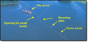 costs to protect Louisiana embayments.
 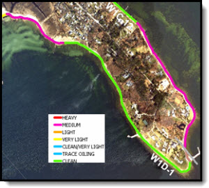 impacts, movement of oil, and conditions related to the accident as part of a class action suit.
 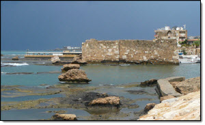 Israeli bombs in July 2006. As a result, part of the oil was burned while the rest, approximately 15,000 tons, was released into the adjacent Mediterranean Sea. The task was to complete an economic evaluation of the impacts based on injury to natural resources (fish, bottom fauna, birds, subtidal biota, marine mammals, and marine turtles) and direct and indirect losses to coastal communities, including hotels, restaurants, fisheries, national parks, and other entities sustaining losses. The overall damage and cleanup costs are conservatively estimated to be about US$ 203 million, or 1 percent of Lebanon's GDP in 2006.
 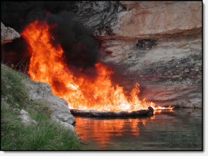 to an excavator which damaged, but did not break the pipe. The break occurred because of a pressure build up due to a pig stuck at the damaged location. Oil traversed a drainage ditch and went into one of the largest lakes in Turkey, spreading over tens of km of shoreline and offshore waters.
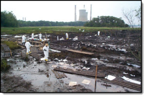 was detected. Altogether approximately 126,000 gallons leaked into the adjacent marsh and then into the Patuxent River. In spite of boom rapidly being deployed, oil spread some 17 miles to the south, eventually oiling a total of 40 miles of shoreline. Oiled habitats include extensive marsh areas, narrow fringing marshes, sand beaches, riprap and harbor structures, and some mud-dominated flats.
 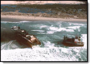 of bunker and diesel oils. After several days of pounding by high seas, the hull was cracked and oil was released. To reduce additional spillage, the oil onboard was lighted, eventually burning approximately 200,000 gallons. The vessel split during the same time, with 150,000 gallons still left in the bow section. Additional burns and attempts at pumping off the oil were unsuccessful. As part of the contracted Spill Management Team responsible for all clean-up related aspects, services were provided as Planning Section Chief, responsible for the daily process of developing the Incident Action Plan, tracking the 300-person response effort, incorporating salvage and environmental professionals into a single Unified Command Organization, and planning for future events.
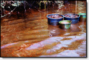 terminal resulted in the release of approximately 40,000 bbl of light Nigerian crude oil. Because of rapid westerly transport, dispersants were the method of primary response, with approximately 250 barrels being applied. Also, because over 90% of the oil was dispersed offshore, heavy shoreline oiling was limited and localized. However, due to westward transport by nearshore currents, remnants of the spill tracked 5-10 km offshore from the spill source was observed at Lagos harbor, about 900 km away.
 Kentucky, spilling approximately 250 million gallons of slurry into adjacent Coldwater and Wolf Creeks. The slurry leaked from a containment pond and into nearby abandoned mine shafts. The spill affected ten counties in northeastern Kentucky, West Virginia and Ohio.
 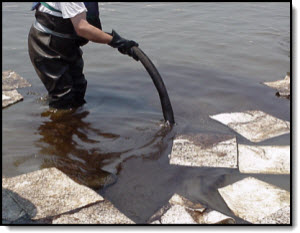 An interactive database of oil spill sorbent products was developed using HyperCard to ensure compatibility with existing U.S. Coast Guard and NOAA programs. By defining the characteristics of the oil spilled, and the environment to be protected, the database will provide the most appropriate sorbents to be used, their manufacturer / distributor, and an estimated cost. The database was developed for installation into the MSO’s existing Cameo-based system.
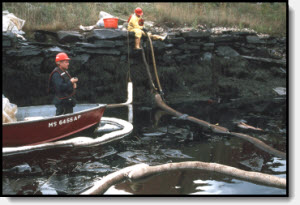 Even though the response was almost immediate in terms of placing booms around the vessel as it docked, substantial parts of the harbor shorelines and offshore waters were oiled. For this spill, Dr. Gundlach participated as part of the SCAT field survey crew and performed surveys to follow impact and recovery of marsh areas.
 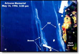 A series of GIS-developed maps were prepared from detailed analysis of video and still photographs that illustrated the distribution and concentration of spill oil through time. Oil coverage was divided into heavy and light concentrations for each day of the survey. The report with accompanying maps assisted in reaching a settlement between the spiller and the natural resource Trustees regarding potential damages caused.
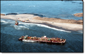 grounded on Moonstone Beach in southern Rhode Island after the tug caught fire and lost power. Together an estimated 828,000 gallons of home heating oil was spilled. Oil spread throughout a large area of Block Island Sound, including Trustom Pond National Wildlife Refuge, resulting in the closure of a 250-square mile area of the Sound for fishing. Hundreds of oiled birds were recovered in the weeks following the spill and large numbers of dead lobsters, surf clams and sea stars were found on area beaches. Government analyses determined that 9 million lobsters were killed by the spill, as well as 19 million surf clams, 4.2 million fish, and over half a million kilograms of marine biomass such as worms, crabs, and mussels. In the salt ponds, 6.5 million worms and other amphipods, more than one million crabs, shrimp, clams and oysters, and another half-million fish were killed. Birds were also harmed by the spill; 2,300 marine birds were killed, including 402 loons. In addition, there were five to ten fewer piping plover chicks hatched at Trustom Pond National Wildlife Refuge. The principal role carried out during this spill was to participate as the owner’s representative in all Shoreline Assessment surveys.
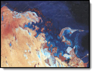 that primarily affected the coastlines of Kuwait and Saudi Arabia. Because of the local current, wind patterns, and configuration of the coastline in Saudi Arabia, significant impacts to the shoreline occurred in Saudi Arabia. As part of an international team to assist the Saudi government and their contractor (Bechtel Engineering), service was provided to evaluate ground and aerial information to determine the extent of oiling, including length, width, and depth of oiling along all shoreline types. To assist the cleanup effort, each shoreline was also characterized in terms of preferred cleanup method and quantity of oiled material to be removed. Shoreline segment was then prioritized numerically for cleanup.
  burned 99,000 metric tons and spilled 25,000 metric tons of heavy Iranian crude oil before sinking near the harbor of Genoa on the Italian Riviera. The spilled oil heavily impacted the exposed beach and rocky shoreline environments from Arenzano to Cape Noli and approximately 140 km2 of the deep-sea sediments (100 m to 400 m water depth) in the Ligurian Sea. Soon after the spill, team participation and supervision was provided to Tecnologie Progetti Lavori SpA (TPL) in Rome, Italy. Technical advisory included including spill fate and mapping, shoreline resources, ecology, and resource economics.
 n route from Bulgaria to Providence, Rhode Island, grounded on Brenton Reef in Narragansett Bay off Newport, Rhode Island. The impact of the grounding ruptured nine of the vessel's 23 cargo tanks causing the discharge of approximately 290,000 gallons of number 2 fuel oil into the bay. The oil eventually spread over a 123 square mile area of the bay and Rhode Island Sound including stranding on intertidal areas in lower Narragansett Bay. The spill adversely affected numerous species of marine organisms including large numbers of adult crustaceans, fish, shellfish and crustacean eggs and larvae, and a variety of benthic organisms in certain heavily oiled locations. The primary activity performed during the spill was to conduct aerial surveillance and provide computer-based (GIS) maps of spill location.
 while navigating into the Mississippi Delta region. In all, 10,000 tons of Venezuelan heavy crude oil were lost. Carried by currents and winds, the oil was transported westward across the northern Gulf of Mexico to the Galveston (Texas) coastal area where it came ashore along a single, 12-mile stretch of shoreline. Technical advice was provided to the U.S. National Oceanic and Atmospheric Administration and the U.S. Coat Guard concerning the fate and persistence of the incoming oil, as well as specific areas to be boomed to protect sensitive lagoons. After oil impact, recommendations were provided for cleaning up the beaches using both mechanical and manual labor. Working with the State of Texas, NOAA, and the U.S. Environmental Protection Agency, disposal sites were analyzed and designed close to the oiled beaches so that cleanup costs, borne by the spiller, would be reduced. Because of the cooperative role between the spiller and the state and federal agencies, the response group also worked closely with the cleanup contractors in advising on beach processes and preferred cleanup methods.
 entrance to La Coruña harbor in northwest Spain on 12 May 1976. A total of 100,000 tons of Persian Gulf crude oil was lost, of which about 30,000 tons washed onto shoreline environments. This project directed a field team and studied the spill during May and June 1976, and again during a follow-up investigation in May 1978. Oil was found to penetrate deeper and form thicker layers on beaches composed of coarser sediments. On fine-sand beaches, oiled sediment was limited to thicknesses of 10 cm or less, whereas on gravel beaches it reached thicknesses up to 65 cm. On rocky shores, oil distribution was related to wave energy. Along high-energy cliffs or steeply dipping rocky areas, wave reflection kept the oil approximately 5 m offshore and contamination was minimal. In low-energy sheltered areas, oil readily accumulated and smothered attached benthic organisms. A follow-up study found most of the previously oil area normal in appearance, except for some deeply buried (and thick) oiled-sediment layers.
 oil/shoreline interactions in a variety of habitats, calculate a spilled oil mass budget, monitor the beaches in terms of biological effects and oil persistence, and to determine, via scuba diving and participation in French-sponsored research cruises, the extent of oil incorporated into bottom sediments.
 he Trans-Alaska Pipeline at Milepost 66, just north of the Continental Divide of the Brooks Range. The objectives of the study were to determine (1) the distribution of remaining oil, (2) the surface area of flooded or low-lying willows that may have accumulated oil, (3) the number of vegetated and non-vegetated channels that were likely to have been oiled, and (4) the extent of probable oiling of the thaw bulb at the pipeline break. The best estimate is that slightly less than 1500 barrels was lost to the environment.
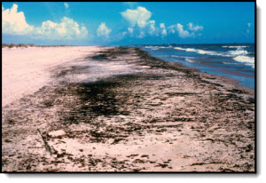 at least 476,000 tons of oil into the Gulf of Mexico until being capped on 24 March 1980. Approximately 3900 tons of oil impacted the south Texas coastline in August and September 1979. As part of a major effort by federal and state agencies to combat the spill, direction was provided to the team that made daily measurements as to the quantity and distribution of the incoming oil, determined major areas of possible biological impact, organized nearshore diving and oceanographic surveys to determine the influencing processes and currents, and provided on-scene reports to the scientific community. The majority of oil was removed by a major mid-September storm; however, post-spill surveys continued for an additional year to determine the persistence and location of Ixtoc I "tar mats" and longer-term biological effects.
  l waters. The barge ruptured off the northeastern shore of Puerto Rico in December 1978, resulting in a loss of 440,000-460,000 gallons of Bunker C fuel oil. Altogether, 26 km of sand beaches, coral beach rock, and mangrove swamps were oiled. Activities included field investigation throughout the duration of the spill and continued impact analyses over the following year.
 supertanker Metula which released over 50,000 tons of crude oil within the eastern Strait of Magellan in August 1974. Carried by strong wind-generated and tidal currents, the Saudi Arabian crude spread over more than 100 km of shoreline. Because of the chance to observe spill effects and influencing coastal processes first-hand, the spill attracted the attention of the international scientific community. The first study in August 1975 determined the great similarities exist between Patagonian coastal environment and areas that were glacially included in the United States, particularly New England, Alaska, and Washington State. Further studies were undertaken in January 1976, August 1976, and February 1981, and in December 1995. Key findings were that (a) sheltered tidal flats and marshes showed long-term damage from the spill; (b) active beaches retained oil only across the spring-tide swash line and along the toe of the beach; (c) oil did not remain on the surface of exposed tidal flats; and (d) long-term biological damage was limited to sheltered tidal flat and marsh areas.